Abstract
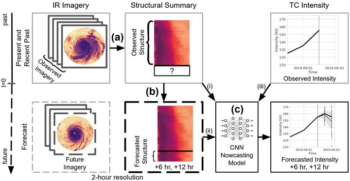
Because geostationary satellite (Geo) imagery provides a high temporal resolution window into tropical cyclone (TC) behavior, we investigate the viability of its application to short-term probabilistic forecasts of TC convective structure to subsequently predict TC intensity. Here, we present a prototype model that is trained solely on two inputs: Geo infrared imagery leading up to the synoptic time of interest and intensity estimates up to 6 h prior to that time. To estimate future TC structure, we compute cloud-top temperature radial profiles from infrared imagery and then simulate the evolution of an ensemble of those profiles over the subsequent 12 h by applying a deep autoregressive generative model (PixelSNAIL). To forecast TC intensities at hours 6 and 12, we input operational intensity estimates up to the current time (0 h) and simulated future radial profiles up to 112 h into a “nowcasting” convolutional neural network. We limit our inputs to demonstrate the viability of our approach and to enable quantification of value added by the observed and simulated future radial profiles beyond operational intensity estimates alone. Our prototype model achieves a marginally higher error than the National Hurricane Center’s official forecasts despite excluding environmental factors, such as vertical wind shear and sea surface temperature. We also demonstrate that it is possible to reasonably predict short-term evolution of TC convective structure via radial profiles from Geo infrared imagery, resulting in interpretable structural forecasts that may be valuable for TC operational guidance.